 |
| Mt. Rainier peeks out of the clouds |
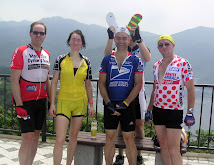
The Cascade 1200 wrapped up Tuesday evening June 26 in Monroe, Washington, after just over 1200 kilometers and 88+ hours. A group of us waited at the last checkpoint, including myself and the two Japanese who rode the 1200 km version, M. Inagaki and J. Sato., as well as Will Danicek, Bob Koen from BC, Matthew O'Niell (who had just switched to a recumbent and never previously ridden it more than 200 kms) and others. We rode together to the finish in a final, relaxed parade.
The ride's website is here. Some photos taken by the organizers/volunteers are here. My complete photos are here. GPS maps and cue sheets for the course can be found here. A nice Japanese language series of blog posts about the ride by Jun Sato can be found here.
With two exceptions (who "rode through"), all the riders stayed at 3 specified overnight control locations, and completed the ride in somewhere between 80 and 90 hours.
There were 80 riders, and 45 volunteers, some of whom helped throughout the entire 4 days. They served breakfast, dinner, and food at many of the other controls. They recorded our times, offered help with equipment, passed on the weather forecast, guided us to our sleeping places -- and made sure we awoke at the time we had requested.
I wish I had counted the number of rivers and streams I rode along or crossed on this trip. 50? 100?
Many veterans, including Ken Bonner, one of the two "through riders", told me at the start that this is a harder ride than the BC Randonneur-sponsored Rocky Mountain 1200 I will attempt next month -- indeed, this is perhaps the hardest regular 1200 km randonee in North America. This year 80 riders started. Registered riders came from the USA, Canada (mostly BC Randonneurs), UK, Japan, Sweden, Germany and Australia. There were 20 "DNFs" and 60 completions -- a low completion rate for a group made up mostly of people who did Paris-Brest-Paris last year and have done other 1200's before, and all of whom needed to ride a 200/300/400/600 km series in either 2011 or 2010 to qualify for registration.
 |
| Heading out from the start at the back of the lead group |
But how hard one of these rides feels depends much more on individual circumstances than on the route itself, and I was happy to have relatively few, relatively short periods when I was thinking "I cannot believe I signed up for this". Yes, it was very hard. Yes, I felt some pain at times -- feet, butt, back, knees, etc. And yes, near the top of Washington Pass on the 4th and last morning, as my hands turned to ice in the cold rain, I wondered "how fast can I descend without getting hypothermia?" and ended up creeping down into a headwind at around 20 kph on a hill I would normally descent at over 50 kph without significant effort. One shivering rider quipped "randonneuring, what a stupid sport", and at that moment I had to agree.
 |
| Resting, on the cold climb up Washington Pass |
But generally my condition was good, and I rode without pain. And there was a lot of spectacular scenery, with time to enjoy it as it rolled by, to chat with the volunteers a bit at controls, and to eat, shower and sleep (some) each night. So for me it was NOT a more difficult ride than PBP. It was a lot easier, a result of more sleep, better support, more planning, and some minor tweaks to my equipment.
A few things stand out -- apologies for an overly long post:
1. The incredible organization and volunteer effort by the Seattle International Randonneurs (SIR).
There were 80 riders, and 45 volunteers, some of whom helped throughout the entire 4 days. They served breakfast, dinner, and food at many of the other controls. They recorded our times, offered help with equipment, passed on the weather forecast, guided us to our sleeping places -- and made sure we awoke at the time we had requested.
 |
| RUSA President Mark Thomas serves us "pour over" style gourmet coffee |
The Day 3 control at Mansfield, a tiny outpost with one Mercantile store in the middle of a vast high plain, was a good example.
As I rolled up and dismounted, one volunteer offered to hold my bicycle and find a place to lean it. A second offered to refill my water bottles. I walked a few feet over to the tent, plunked down on the lawn, was offered by Dan Jansen (one of the "Team Voisins" group from PBP) my choice of about 10 varieties of sandwich, cold drinks, cookies. They even had individual packets of Chamois Butt'r cream for anyone whose butt was feeling a bit sore.
No waiting in lines at controls. Plenty of food and drink. Never needed to get out the wallet at a Control. Never "sorry, we ran out of water 15 minutes ago" for those of us in the middle or toward the rear of the pack. Always "sure, take an extra PBJ sandwich, cookie and banana in your bag to eat on the road".
 |
| At the Control #12 in Malott, nearing the end of Day 3 |
(There were actually MORE than 45 volunteers, since some of the riders who DNF'ed converted into volunteers. Thanks, Ed Groth, for bringing me hot coffee and a pair of new, dry, warm, waterproof work gloves from the Skagit General Store in Newhalem, WA, as I rested).
2. The variety and vastness that is Washington State.
 |
| Take this road for 22.5 km straight, then turn left onto a similar road for another 20.7 kms. |
I know this territory a bit, having grown up in Portland, Oregon, gone on a family car trips long ago at least as far as Grand Coulee Dam and Mount Baker, and enjoyed Boy Scout events hiking around Mt. Adams and as working as a counselor at Camp Spirit Lake near pre-eruption Mt. St. Helens. But the areas in central/eastern Washington made a much bigger impression on me on a bicycle this week than they did when I went through them in a car as a child. Some thoughts on the route:
The western foothills.
The first 100+ mile stretch and last 100+ mile stretch, each along the edge of the western foothills of the Cascades, took us through a mix of prosperous looking ex-urbs of Seattle/Tacoma, and semi-depressed logging towns. As we rode across the Green River, the rain falling and dark clouds overhead, I could only think that this is where the "Green River killer" dumped the bodies of his victims. Silence of the Lambs. But the area looked reasonably prosperous, and I guess it is unfair to associate it with a serial killer, just as much of Fukushima Prefecture is far away from the nuclear plants that melted down last year ... but now will always be associated with that disaster. |
| East of Elbe, near the entrance to Mt. Rainier National Park |
All along these stretches, the cars were primarily huge pick up trucks, or huge SUVs. Sure, there are plenty of Toyotas and Nissans along with the Fords and GMCs. But they are Toyota Tundra trucks and Nissan Armada SUVs. Trucks on steroids. Low MPG. And they go fast. But the drivers were mostly courteous and gave us a wide berth, and the shoulder was mostly wide enough so as to leave an escape area for those few drivers who did hog the road and honked their horns (mostly these were trucks/SUVs pulling trailers that were less stable if they swerved to give cyclists a wide berth). The real "eighteen wheeler" big rigs all gave us a wide berth, and I did not feel threatened despite the high speed at which they traveled. And 90%+ of the route had VERY LOW traffic volume. Come to think of it, there were almost NO red lights/traffic signals the entire 4 days.
 |
| Jackie's Java in Elbe |
One California participant had told me that Enumclaw, near PC2, is full of pickup trucks and that folks would be out on their front porches playing the banjo. Deliverance. We did not actually go through Enumclaw, so I cannot comment. But at least in nearby Elbe the girls at Jackie's Java were friendly and smiling, despite the rain.
On day 4, we passed through similar country along the Skagit River through Marblemount to Rockport, then on SR 520 through the forest to Darrington with its big lumber mill. This area looked a bit more depressed, darker and colder. It was mid-day on Tuesday as we passed through Marblemount and looked for a restaurant. Most of the choices were closed. The heavy guy at the Marblemount store did not seem eager to help when I asked about restaurant choices, but he did direct us to a place about 2 miles out of town which turned out to be open and served a tasty lunch for Inagaki-san and me, as well as several other riders who were dining already as we rolled up, one of whom claimed to being a "regular" whenever he rode through that area. Darned good hot coffee there! And more good hot coffee again a bit later at the diner in Darrington! This area up near Canada and nestled against the Cascades sure feels like Twin Peaks.
Spectacular sunsets, stars and rushing waters.
The descent from White Pass down to Naches was spectacular, especially the section beyond Clear Lake/Tieton Lake after dusk, with more stars visible than I had seen at least any time this year, and with the Tieton River rushing alongside the road. Riding this stretch at night, and again the stretch at the end of Day 3 along the Methow River to Mazama, reminded me how much I love riding a bike in the dark, when there is almost no traffic and you can see a million stars and hear the waters of a river running nearby. What a great feeling. And despite the rain, on each of Days 1, 2 and 3, we could see clouds turn orange, pink and/or red against a darkening blue sky background as the sun set.
 |
| Day 1 as sunset nears, at Tieton Lake |
Dams and Power Lines; Irrigated Agriculture.
The Columbia River is impressive, but what really stand out are the number of dams and reservoirs along its route, and the high tension power lines criss-crossing the nearby landscape.
 |
| Chief Joseph Dam on the Columbia just above Bridgeport, Washington |
At the entrance to each town in parts of central Washington, there is a sign "Welcome to XXYY, another Public Power Community". Municipally-owned utilities! The irrigation water from rivers, and the cheap hydropower to pump it where it is needed, are the lifeblood of this part of the state. Without it, this entire region would just be sage brush and rocks. With it, it is incredibly productive farmland -- hops, alfalfa, wheat, cherries, vineyards, apple orchards, and on and on. The scale is huge -- food for millions, not thousands. When, on the dusty road into Mattawa, I passed a vineyard stretching as far as my eye could see toward the North, I could not help but think that this one farm might produce as much wine as all of Yamanashi Prefecture's "fruit bowl" around Katsunuma and Koshu/Kofu.
 |
| Hops as far as the eye can see, on SR 24 east of Yakima. A 47 km straightaway. |
On Day 2 somewhere around Yakima I saw a politician's banner "vote Mr. X for [legislature]". The banner noted that he is a former U.S. Army officer, and his slogan was against "wasteful spending" by the folks in Olympia (capital of Washington State). I laughed to myself. Here was an example of someone whose entire lifestyle is a result of Federal spending that built the dams and provide the cheap electricity and irrigation, and who was even a Federal employee for his working life (the U.S. military being the biggest part of the Federal workforce), who must be getting Veterans' Administration healthcare unless he is old enough for Medicare -- another Federal program, and he is campaigning against "wasteful spending". I wonder whether he has paid enough taxes over his life to pay for one quarter of what he has received from all that "wasteful spending"?
 |
| Escarpment on the Columbia across from Beverly, WA |
Hispanicization (if there is such a word).
If agriculture is the main industry in much of central/eastern Washington, then the work force is mostly Hispanic. And over the generations, people who were once migrant workers have settled down and raised families. Many of the larger towns seemed to be clear majority ethnically Hispanic. This was especially evident in Brewster and Bridgeport, on Day 3, and from looking at the families strolling along the Yakima Greenway path on Day 2. The ethnic make-up of the U.S. is changing steadily, and it very much evident in central/eastern Washington.
Climbing Loup Loup Pass, Washington Pass, the aptly-named Rainy Pass, and White Pass.
Even though the GPS profiles suggest there is something like 38,000 feet of ascent on the Cascade 1200, the ride did not strike me as having particularly tough climbs. On the morning of Day 2, we started by "climbing" 45 miles (73 kms) up the Naches River and to Lodgepole Campground a few miles short of Chinook Pass. But we only gained 2000 feet (650 meters) over this stretch. It was a very tough stretch, but entirely due to headwinds, not because of the climb. Death by a thousand little cuts.
 |
| Day 2 -- Approaching Lodgepole Campground |
 |
| On the climb to White Pass |
On Day 1, the big climb was over White Pass, Elev. 4500 feet. It was a long slog at relatively shallow gradients, and should have been easy. Unfortunately, I forgot to refill my water bottles at Packwood and so needed to beg a few hundred milliliters of water from each of two other riders in order to get over a "bonk" and make it to the top.
Likewise, the climb to Washington Pass (and then the aptly-named Rainy Pass) at the beginning of Day 4 is not any more difficult than Yanagisawa, Matsuhime, or even Kazahari Pass near Tokyo. Unfortunately, the lack of sleep (2 hours or less) at Mazama, and the fatigue of the 3 previous days, made this a tough ascent for me, and I struggled, rested, ate, relieved myself, etc. numerous times before getting to the top. The weather was a major challenge. The scenery was very impressive, and would have been more so if the clouds had lifted a bit. It reminded me of the opening of The Shining. The top of the pass is 5477 feet elevation, and the snow level the previous night had been as low as 5700 feet. It was around 2 degrees C/36 degrees F and raining hard as we crested the pass on Tuesday morning.
 |
| On Loup Loup Pass |
That leaves my favorite, Loup Loup Pass, which we crossed near the end of Day 3. This pass started with a stretch at 10% grade climbing, then moderated, even dipped a few hundred feet at one point, and then continued at a reasonable 6-8% grade all the way up to 4020 ft elevation. We climbed it in cool, dry weather, late in the day, and I felt good most of the way up, though waiting a few times for others.
Winthrop and Surrounding Areas.
As mentioned, I like nothing better than riding at night with low traffic, a river nearby, and stars overhead. The Methow Valley from Twisp to Mazama gave me this. The Methow River drains a large piece of the Pasayten Wilderness, where my son Henry spent 30 days on a NOLS backpacking course last summer. And a real surprise was the town of Winthrop, which has done a "western restoration" and has a large western-themed area in its center, complete with old west saloons, boardwalks, theaters, and various other wooden structures. It was fun to come upon this and see the lights and hear music playing in the saloon, at 10PM on a Monday night, as I rolled through. I would love to go back in the daytime. Of course, this area is no Provence or Tuscany, as signaled by the name on the campground a few miles up the road from Mazama -- "Early Winters Creek Campground". There also should be a "Late Spring Creek" and maybe a "Short Summers Creek".
3. Preparedness -- Equipment and Physical Condition.
There is a certain randomness to the results of these long events. Often, a DNF is a result of a problem with equipment that cannot be made safe or usable, even though the equipment started the ride in good condition and has an excellent record for reliability. One of the DNF's this year was a recent former winner of the Furnace Creek 508, who was riding the Cascade 1000km alternative with his partner this year, but who could not start Day 3 due to equipment issues. So as in many things in life, it is better to be lucky than good.
 |
| Wider wheel rims and tires, lower tire pressure, more bar padding, dynamo lighting and room for plenty of gear |
But it is also important to do everything you can to improve your odds. Looking back at PBP 2011 and even my recent Tohoku 1700 rides, I made some key changes to my equipment and ride plan. Especially, I dealt with every issue identified following PBP:
a. Wheels, Tires and Bartape.
The only five contact points with the bike are my two hands, my saddle (i.e. groin/butt), and my two feet. The wheels/tires will affect all of these. The bars/bar tape affect the hands. Trouble with any one contact point will force you to compensate and rely more on the others ... which, over 1200 kms, will inevitably lead to trouble with those as well. So you need hands, saddle and feet each to be very comfortable in order to complete a ride like this.
At PBP, I used Mavic Open Pro rims, 36/32 DT Competition spokes, and Schwalbe Ultremo DX 700-23 tires -- a pretty standard road set up, with "bombproof" wheels. But the pain in my hands was almost unbearable on one stretch of bumpy chip-sealed French roads late in PBP. For Tohoku, I switched to 23mm wide Velocity A-23 rims, more flexible DT Revolution spokes (still 36/32) and slightly wider Vittoria Open Pave tires (they are rated 700x24 ... but feel a bit wider). After both PBP and Tohoku, I had some numbness in the little fingers on my hands that lingered for days or even weeks.
For the Cascade 1200, I set up my handlebars with some Fizik gel pads under the bar tape. And I used the old tape to form an inner extra layer of protection between the gel and the new tape. The bars still felt rock solid, but this combination swallowed up the road vibration very nicely. Also, the Open Pave tires on the 23mm Velocity rims are much more comfortable over long distance than the Schwalbe Ultremos. I ran them at 95psi (under 7 bars), and they offered a great combination of road feel, comfort and speed.
And I had NO FLAT TIRES with this pair of tires on either the Tohoku rides (1375 kms) or the Cascade 1200, (or on the 400~500 kms I've ridden them in between these two events, or the similar mileage that preceded Tohoku). On SR 24 east of Yakima, I rode straight through at least 3 glass patches from smashed bottles over a 15 mile stretch. Each time, I waited for the inevitable hissing sound, and reached down with my gloved hand to try quickly to brush any glass off that might be working its way into the tires. There was no hiss, no flat.
b. Chamois Cream.
At PBP, I was rationing chamois cream and riding through wet weather, with inevitable results (lots of redness and chafing in the groin/saddle). This time, I wore only my best bib shorts (Assos!), and brought plenty of chamois cream, and so could ride in relative comfort, as in Tohoku.
c. Feet.
I've had some foot pain on ultra long rides, and so this time changed to somewhat roomier shoes, with a higher arch support, and with some gel pad inserts for metatarsal support (under the balls of the feet), as recommended by other riders from the SIR online "Google groups" email list. This helped. I still had some pain on Day 3 when I caught myself standing and stomping on the pedals more than I probably should have, but otherwise had no problems. I did not get a chance to try my new cycling sandals, which I had saved for Day 4 but was not about to wear in the wet, near freezing weather, without adequate feet coverings. My feet were pain-free throughout Day 4, despite the tighter fit caused by an extra layer of socks and some chemical warmers on top of each foot inside the shoe.
d. Sleep and Jet Lag.
I arrived a day earlier in the Northwest this trip than I did in France before PBP. It made a huge difference. I got exercise on Wednesday and Thursday, and 7 hours of sleep each of Wednesday, Thursday and Friday nights, leading up to the Saturday 6AM start. And at the end of Day 1 and 2, I got 4.5 hours of sleep each night. So despite the incredibly tough ride, and a difficult start on the mornings of Day 3 and Day 4, I was a LOT fresher than at PBP. And I could see the contrast between myself and Inagaki-san, who was still somewhat jet lagged at the start, and did not get much sleep any night during the ride. He looked miserable for long stretches, as I had felt at PBP.
For the Rocky Mountain 1200, I may experiment a bit more with when and how much sleep to get during this type of event -- especially if I can ride a bit faster on the first day or two -- but I think the basic rule is that I should try for over 4 hours a night. If I cut it back, I will likely end up riding more slowly, and be in the same place I would have if I had slept more, but will be feeling much worse.
e. Other Equipment/Supply Fixes.
This time, I used both a front bar and a rear bag, so could carry plenty of food (Clif bars and gels, plus a mix of other foods for variety), clothes for different climates I might encounter during a single day, spares/tools, and the like. I brought 2 one-liter water bottles, which were adequate since we did not face truly scorching temperatures on the eastern half of the ride. In reserver, I had a hydration reservoir and pack in my drop bag as well, in case the weather forecast changed.
Also, of course, I used my dynamo hub generator and LED light, so I had no worries about running through batteries for my lights or getting adequate light on pitch dark roads. I could easily boost the charge on my Garmin Edge 800 with a small rechargeable Eneloop AA battery-based charger, so it lasted through each long day, and could find an outlet to recharge it at night.
Finally, I bought a small supply of coffee flavored caffeine pills at the Narita Airport pharmacy, and ended up taking two of them on the last day when I started fighting to stay awake and not doze off while riding. They worked for as long as needed.
f. Rain Gear.
The only thing that did NOT work well was my rain gear. My full finger gloves got wet almost immediately and did not provide adequate warmth. The shoe covers I had, likewise, were of limited help. My Gore Tex cycling jacket (circa 2004 from Performance Bicycles Rockville shop) is no longer water proof after an hour or two of rain. And my aging half fingered Castelli gloves left my hands red and chafed almost as soon as they got wet. The only item that did work were the dhb rain pants I got last year from Wiggle. But those have no flexibility in the material and I tore a huge gash in the seat when I lifted my leg to dismount the bicycle on Day 4. Also, I had some Sugoi brand waterproof shoe liners/socks that I left at the roadside during a rest stop outside of Quincy when I pulled something else from my bag.
After the ride, I tossed the worn out Castelli gloves and the torn rain pants, and made a trip to REI for a new Pearl Izumi "barrier" rain/wind shell, some REI ultra light rain pants (which have enough room AND stretch in the seat area), plus some Sealskinz brand waterproof socks, that may work with the cycling sandals if they prove too thick for use with regular cycling shoes.
g. Physical Condition
I have not put in near the mileage in 2012 that I did in 2011 before PBP, nor have I planned my training schedule with much care. But I think doing the 1375 kms of Tohoku rides over Golden Week, then 308 km Tokyo-Itoigawa, then a couple of 150 km Sunday rides in more recent weeks, plus shorter "stretch the legs" rides after arriving in the Pacific NW, was just about the perfect preparation for this event. Now, for the next one, I just need to make sure I am fully recovered by July 22.
_________________________
The sum of all these tweaks was that I finished the ride in good form, and I do not feel like I punished myself nearly as much as at PBP, nor as if it should take nearly as long to recover.
Time to start planning for the Rocky Mountains!
UPDATE 2014: The 2014 version of the Cascade 1200 will swing far south to the Columbia River, instead of the somewhat pointless round trip up to Lodgepole campground on the eastern side of Mt. Rainier. I REALLY would love to try this version ... but cannot join this time. Maybe again in 2016?
UPDATE 2014: The 2014 version of the Cascade 1200 will swing far south to the Columbia River, instead of the somewhat pointless round trip up to Lodgepole campground on the eastern side of Mt. Rainier. I REALLY would love to try this version ... but cannot join this time. Maybe again in 2016?


3 comments:
Congratulations! Great ride.
Nice one David, great achievement. Congratulations.
Very impressive! Congratulations on finishing so well. What is next? 2,000km??
Post a Comment