

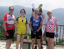
Glorious 5 hrs of riding of 120km and 900m vertical (UPDATED from 1400m via the Elevation Police) today.
Michael, Graham & I headed over Yabitsu, meeting Tom on his way down, whilst David & Dominic headed back to Tokyo along Route 20 after joining us along Tank Road first thing.
Took some video with my ContourHD camera throughout the ride, although using the bike mount there was far too much vibration. I took a 12min clip from the descent into Hadano and my Mac needed 2 hours to "Analyze for Stabilization". You can see the results below. We returned via Shinkansen from Odawara which added a useful 20km along the coast to our ride plus was far more time efficient in getting home. Thanks guys, good day.

First 'Tank Park'
Second 'Yabitsu Descent'


5 comments:
James:
Nice (stabilized) video! How did you affix your camera to the bars? I was thinking that a "helmetcam" set up might work well b/c it would not get the direct road shock, but have yet to try it. And I don't have the benefit of Mac video editing software (though I suppose I could try to take over my wife's Mac).
The 1400 meters elevation gain sounds a bit much for a trip out One-kansen and Yabitsu climb ... but not as much of an exaggeration as Tom's 10,000 meter rides out in Yamanashi.
I think the elevation is touch on the high side too.. prob more like 900m rather than that shown at Garmin Connect.. the guy I bought the camera from sent me a bike mount for my camera.. basically something to attach to a circular tube.. I - as you can see - had it attached to lower part of the handlebar.. a good place, but the vibration it picked up was annoying to say the least.. attaching to the helmet might be the answer.. or going back to handheld.. but then filming descents becomes a little more exciting off the brakes!
The problem with the elevation is most likely that the map software does not adjust for tunnels, but calculating on the basis of the original landscape contour as we know. But having said this, there are no substantial tunnels out on the Yabitsu approach.
I like the videos and the combination with the music. I wish I had some "digital frame" in my room where I could run that so that I will be distracted from the work on my desk.
"The device has a sensor built into it that will measure the ambient air pressure around the device. Ambient air pressure can change due to weather and climate. There is not a way to go in and manually calibrate the altimeter, therefore the first altimeter reading will spike and base its reading on the last place the unit was able to receive satellite reception. Another wards, the first reading is based off of gps elevation. The more the gps device is used the more accurate it should become. The more information the device has it will auto-calibrate itself over time, averaging information to become more accurate." via Garmin
I thought it measured altitude solely via air pressure... it appears not.., as they say.. ride more!
Somehow that part of the Tank Rd looks unfamiliar to me. Were the barriers at the end of the video the ones that lead to a steep slope, and then the water tower? (in the direction of Minami Osawa)
Post a Comment